
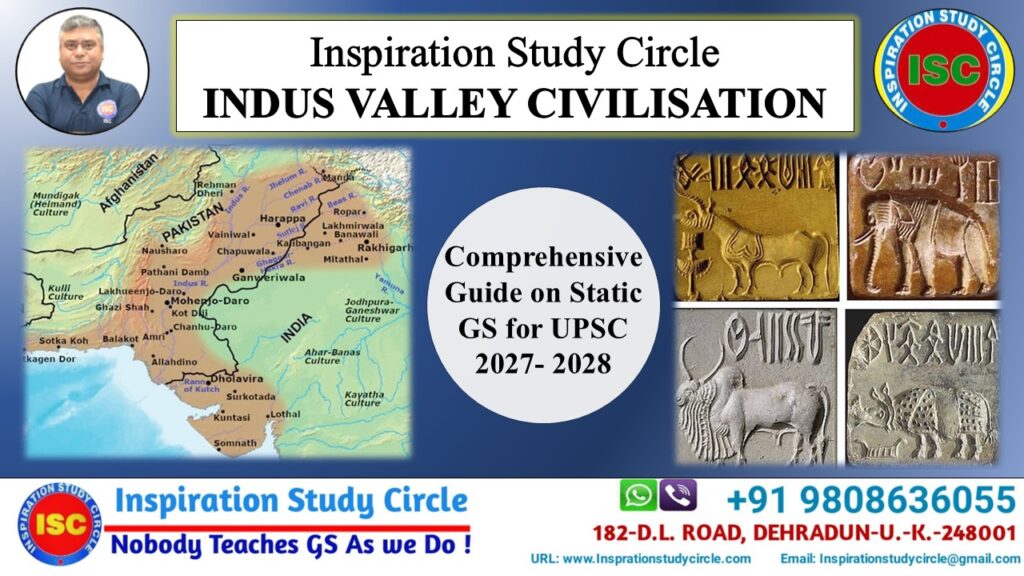
Indus Valley Civilisation: A Comprehensive Guide for UPSC 2027-28
Table of Contents
The Indus Valley Civilisation (IVC), also known as the Harappan Civilisation, was one of the world’s earliest urban societies, flourishing around 2500 BCE to 1900 BCE during the Bronze Age. Spanning across present-day northeast Afghanistan, Pakistan, and northwest India, it is globally renowned for its advanced engineering, spectacular grid-based town planning, and highly evolved civic sense.
Geographic Extent and Core Sites
The civilisation covered an area of nearly 1.3 million square kilometres. It extended from Sutkagan Dor (Baluchistan) in the west to Alamgirpur (Uttar Pradesh) in the east, and from Manda (Jammu) in the north to Daimabad (Maharashtra) in the south.
1. Harappa (Punjab, Pakistan)
Excavated by Daya Ram Sahni in 1921, this was the first site discovered, making it the type-site of the civilisation. It was located on the banks of the old bed of the Ravi River.
- Key Findings: Two rows of six granaries with strategic air vents, working floors used for pounding grain, a red sandstone male torso showcasing advanced anatomy, terracotta figurines, and a crucible for bronze smelting.
- UPSC Insight: Harappa reveals a highly organised labour force. The proximity of the granaries to the river indicates an economy heavily reliant on riverine trade networks for food distribution.
2. Mohenjo-daro (Sindh, Pakistan)
Discovered by R.D. Banerjee in 1922, its name translates to the “Mound of the Dead.” It sits on the right bank of the Indus River and represents the peak of Indus urbanisation.
- Key Findings: The Great Bath (a large bitumen-lined public pool), the Great Granary (the largest building at the site), the bronze Dancing Girl (cast via the lost-wax technique), the steatite Bearded Priest, and the Pashupati Seal (depicting a seated deity surrounded by an elephant, tiger, rhino, and buffalo).
- UPSC Insight: The Great Bath points toward ritualistic purification practices, while the complete lack of palaces or military fortifications indicates a socio-political structure ruled by merchants or civic administrators rather than a warrior king.
3. Dholavira (Gujarat, India)
Located on Khadir Bet in the Rann of Kutch, this site was excavated by R.S. Bisht in the 1990s and is a UNESCO World Heritage Site.
- Key Findings: A unique three-tier town planning system (Citadel, Middle Town, and Lower Town) unlike the standard two-tier setup. A massive, sophisticated network of interconnected water reservoirs, dams, a large sports stadium, and a signboard containing ten large-sized characters of the Indus script.
- UPSC Insight: Dholavira is the ultimate example of Harappan environmental adaptation. Situated in an arid zone, its hydraulic engineering and rainwater harvesting systems showcase a profound understanding of conservation that mirrors modern climate adaptation strategies.
4. Lothal (Gujarat, India)
Excavated by S.R. Rao in 1954, Lothal was situated on a tributary of the Bhogavo River, near the Gulf of Khambhat. It served as the empire’s industrial engine.
- Key Findings: A massive, tidal artificial brick dockyard connected to the river, a bead-making factory with raw carnelian workshops, Persian Gulf-style seals, twin burials (suggesting joint cremations), and terracotta models of a ship.
- UPSC Insight: Lothal is proof of the international maritime character of the IVC. The presence of Persian Gulf seals proves direct overseas trade with Mesopotamia and Dilmun (modern Bahrain), establishing the Harappans as master navigators.
5. Kalibangan (Rajasthan, India)
Located on the banks of the dried-up Ghaggar River, this site was excavated by Amlanand Ghosh and later by B.B. Lal and B.K. Thapar. Its name means “Black Bangles.”
- Key Findings: Evidence of the world’s earliest ploughed agricultural field, a series of fire altars on platforms (suggesting fire worship), camel bones, and distinctive pre-Harappan and Harappan pottery phases.
- UPSC Insight: The ploughed field grid pattern shows they grew two crops simultaneously (likely mustard and chickpeas). The fire altars present a cultural divergence from the Mohenjo-daro population, highlighting regional variations within the unified civilisation.
6. Rakhigarhi (Haryana, India)
Situated in the Hisar district along the dry bed of the Ghaggar-Hakra River, excavated by Amarendra Nath.
- Key Findings: Extensive mud-brick structures, sophisticated drainage, a jewellery-making unit for precious stones, and a large cemetery with skeletal remains. Recent DNA analysis of these skeletons has added crucial data to the study of South Asian ancestry.
- UPSC Insight: Spanning over 350 hectares, Rakhigarhi has overtaken Mohenjo-daro to be classified as the largest geographical site of the civilisation. It proves that the centre of gravity of the IVC was evenly distributed between the Indus Valley and the Ghaggar-Hakra plains.
7. Chanhudaro (Sindh, Pakistan)
Located south of Mohenjo-daro, this site was excavated by N.G. Majumdar in 1931.
- Key Findings: It is the only Harappan city without a fortified Citadel. It was a dedicated manufacturing hub containing bead-makers’ shops, metal-workers’ tools, shell-cutters’ benches, and a small terracotta inkpot.
- UPSC Insight: Chanhudaro’s purely industrial nature confirms a highly specialised division of labour. The absence of a citadel implies it was an economic suburb or industrial colony heavily dependent on surrounding major capitals for administrative security.
Quick Comparison Matrix for Revision
| Site Name | Key Geographic Feature | Primary UPSC Diagnostic Finding |
| Harappa | Ravi River | Row Granaries / Working Floors |
| Mohenjo-daro | Indus River | Great Bath / Pashupati Seal / Bronze Gymnast |
| Dholavira | Rann of Kutch (Arid) | Triple Town Layout / Reservoirs / Inscription |
| Lothal | Bhogavo River / Coast | Tidal Dockyard / Bead Factory |
| Kalibangan | Ghaggar River | Ploughed Field / Fire Altars |
| Chanhudaro | Indus River Basin | No Citadel / Industrial Bead Hub |
| Rakhigarhi | Ghaggar-Hakra Plains | Largest Site Footprint / Ancestral DNA Studies |
Salient Features of IVC
1. Town Planning and Architecture
- Grid System: Streets intersected at right angles, dividing the city into rectangular blocks.
- Fortification: Cities were generally split into a fortified Citadel (west) for the ruling class and a Lower Town (east) for commoners.
- Building Material: Exclusively used standardised, kiln-burnt mud bricks with a ratio of 4:2:1.
- Drainage System: Advanced covered drains lined with mortar, gypsum, and cesspits for regular cleaning. Every house had its own courtyard and bathroom.
2. Economy and Trade
- Agriculture: First in the world to produce cotton (referred to as Sindon by Greeks). Main crops included wheat, barley, mustard, peas, and sesame.
- Trade Networks: Flourishing internal and external maritime trade. They maintained active trade links with Mesopotamia (Sumeria), Persia, and Oman. Mesopotamian texts refer to the IVC as Meluha.
- Weights and Measures: Highly standardised weights based on the binary system (1, 2, 4, 8, 16, 32, up to 64) and decimal multiples.
3. Society, Religion, and Culture
- Script: Pictographic and logo-syllabic script written in Boustrophedon style (alternating right-to-left and left-to-right). It remains undeciphered.
- Religious Beliefs: Worshipped a proto-Shiva deity (Pashupati Mahadeva surrounded by animals), Mother Goddess (Matridevi), peepal trees, and amulets (indicating belief in ghosts/magic). No temples have been discovered.
- Art and Craft: Mastery in bronze casting using the Lost Wax technique (e.g., Dancing Girl), terracotta figurines, and steatite seals (mostly square with animal motifs like the unicorn).
Decline of the Civilization
The civilisation gradually declined around 1900 BCE. Historians attribute the collapse to a combination of factors rather than a single event:
- Ecological Changes: Shifting or drying up of rivers like the Ghaggar-Hakra system.
- Climate Change: Weakening of monsoons leading to severe, prolonged droughts.
- Floods: Evidence of devastating, repetitive floods at Mohenjo-daro.
- Aryan Invasion Theory: Proposed by Mortimer Wheeler, though widely discredited due to a lack of skeletal evidence of massacre.
UPSC Civil Services Examination Takeaways
Key Analytical Dimensions for Mains
- Urbanisation vs. Modern Planning: Compare IVC drainage, sanitation, and grid planning with India’s current Smart Cities Mission. The IVC highlights that sustainable urbanisation requires decentralised water management and robust civic administration.
- Secular Polity: Note the complete absence of monumental religious structures (like Ziggurats in Mesopotamia or Pyramids in Egypt). This indicates a governance system driven by commerce, utility, and civic welfare rather than religious autocracy.
- Artistic Metallurgy: Understand the technological sophistication of the Lost Wax technique. This proto-historic artwork forms the foundational lineage of Indian sculpture art, extending down to Chola bronzes.
- Environmental Determinism: Analyse the decline as a classic case study of how climate shifts can collapse massive economic systems. It serves as an ancient warning for modern global climate resilience planning.
High-Yield IVC Guidelines for UPSC Prelims
- To clear the Prelims stage, your study should target specific factual indicators, unique discoveries, and geographic alignments. The following point-wise guidelines cover the core areas targeted by recent UPSC question trends.
1. Geographic Alignment and Mapping
- Border Extremities: Remember the four outer points: Manda (North – Jammu), Daimabad (South – Maharashtra), Suktagendor (West – Pakistan-Iran border), and Alamgirpur (East – Uttar Pradesh).
- River Associations: Do not confuse the rivers. Harappa is on the Ravi, Mohenjo-daro and Chanhudaro are on the Indus, Lothal is on the Bhogavo, and Kalibangan, Banawali, and Rakhigarhi are on the Ghaggar-Hakra bed.
- Modern State Locations: Be clear on Indian site distributions. Gujarat holds the highest number of sites (Lothal, Dholavira, Surkotada, Rangpur). Haryana holds Rakhigarhi and Banawali. Rajasthan holds Kalibangan.
2. Diagnostic Material Culture (Pottery, Seals, and Scripts)
- Pottery Characteristics: IVC pottery is predominantly Red and Black ware (red pots painted with black designs of trees, circles, and birds). It was completely wheel-made, and luxury varieties included perforated pottery.
- Seal Composition: Most seals were made of soft river stone called steatite. However, copper, silver, chert, and terracotta seals have also been found.
- Seal Motifs: The most frequently depicted animal on seals is the Unicorn (mythical single-horned beast), followed by the humpback bull. Note: No seals depict a horse or a lion.
- Script Behaviour: The script is purely Boustrophedon (written from right to left in the first line, then left to right in the next). It is logo-syllabic and remains completely undeciphered.
3. Agricultural and Faunal Exceptions (High-Trap Areas)
- Crop Varieties: They were the world pioneers in cotton cultivation. Other primary crops included wheat, barley, peas, mustard, and sesame. Note: Rice remains are extremely rare and found only as husks at Lothal and Rangpur.
- The Horse Question: The Harappan economy was not a horse-centred society. While questionable horse teeth or bones were found at Surkotada, the horse was definitely not domesticated or used in daily life by the Harappans.
- Animal Awareness: They knew of and depicted elephants, rhinos, tigers, buffaloes, and humped bulls. However, they were completely unaware of the lion, and iron was entirely unknown to them (it was a Bronze Age society).
4. Socio-Religious and Political Nuances
- Absence of Temples: Religious life is inferred entirely from figurines and seals (Pashupati, Mother Goddess, tree/snake worship). There is no structural evidence of any temple, shrine, or monumental religious building anywhere in the IVC.
- Absence of Monarchy/Military: No royal palaces, standing armies, or mass weaponry have been excavated. The society was overwhelmingly commercial, likely governed by a guild of merchants or civic committees.
- Class Divisions: While most cities followed a binary layout (Citadel for elites, Lower Town for commoners), Dholavira is a triple-town exception, and Chanhudaro completely lacks a Citadel.
5. Advanced Technology and Commerce
- Metallurgy Limits: They mastered bronze casting using the Lost-Wax (Cire Perdue) technique. They used copper, bronze, gold, and silver, but never iron.
- Urban Infrastructure: The use of standardised burnt bricks (4:2:1 ratio) was universal, contrasting with contemporary Egypt, which relied mostly on dried mud bricks.
- Monetary System: There was no metallic currency. International and domestic trade functioned entirely through a regulated barter system, validated by standard weights made of chert stone following a binary system (1, 2, 4, 8, 16, 32…).